WRAL Meteorologists Track Tropical Storm Imelda and Its Impact on North Carolina
WRAL meteorologists are closely monitoring Tropical Storm Imelda, which formed Sunday afternoon, alongside its interaction with Hurricane Humberto, currently located far off the East Coast. Imelda is forecasted to bring waves of rain to North Carolina, primarily on Monday and Tuesday, potentially leading to localized flooding. This tropical system is expected to be mainly a rain event, with winds not posing a significant concern.
**Latest Updates:**
**8 p.m.**
Tropical Storm Imelda is still forecast to turn east-northeast on Tuesday and remain well offshore of the North Carolina coast. High rip current risks are expected Monday through mid-to-late week, along with rough surf offshore.
**5 p.m.**
Imelda continues to move with maximum sustained winds holding at 40 mph. The storm is on track to bring tropical storm conditions to the Bahamas before delivering rain to the Carolinas on Monday and Tuesday. It is also possible that Hurricane Humberto, a Category 4 storm, could pull Imelda away from the coast.
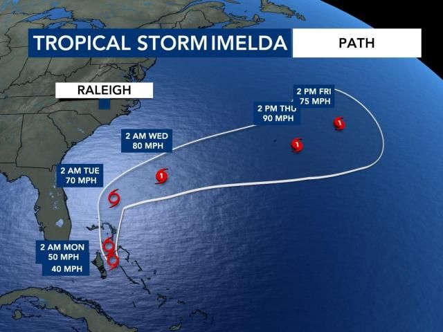
**2 p.m.**
Tropical Storm Imelda has officially formed with maximum sustained winds of 40 mph. The storm is expected to impact the Bahamas with tropical storm conditions and move northward, bringing substantial rain to the Carolinas on Monday and Tuesday.
**11 a.m.**
Hurricane Humberto has intensified to a Category 4 storm located 535 miles south of Bermuda, with maximum winds of 150 mph. Tropical Depression 9 had not yet been named Imelda but was expected to do so later Sunday afternoon. Currently situated 95 miles west of the central Bahamas, forecasts suggest Humberto will pull Tropical Depression 9 away from the coast, reducing rain impacts in North Carolina.
**9 a.m.**
Tropical Depression 9 could be named Imelda later Sunday. WRAL meteorologist Chris Michaels noted the system is moving north and expected to be caught between a weak low over land and Hurricane Humberto to the east. Humberto is predicted to pull the system away from the East Coast by late Tuesday.
“We still expect waves of rain Monday and Tuesday; however, rain totals and flood risks are lower,” Michaels said. “We’ll be breezy, but damaging winds are highly unlikely. Tornadoes are not expected.”
Rain on Monday and Tuesday will not be continuous. “Showers on Monday will start light and scattered, gradually increasing later in the day,” Michaels explained. “On Tuesday, rain will begin heavy and then taper off.”
**7 a.m.**
Tropical Depression 9’s impact on North Carolina may lessen due to Hurricane Humberto, which is forecast to stay far offshore. While Humberto won’t directly impact the U.S., it could pull Tropical Depression 9 farther from the coast, reducing rainfall in the state.
Still, parts of central and eastern North Carolina could experience significant rain Monday and Tuesday. Even if the system remains offshore, periods of rain and localized flooding are possible south of the Triangle region during this time.
Sunday will be mainly dry before rain moves in from the southeast overnight into Monday. Most of the rainfall is expected late Monday and Tuesday, with gradual clearing beginning Wednesday.
“Rain chances will drop Wednesday, thanks to the tropical system being pulled out to sea,” said WRAL meteorologist Chris Michaels. Following Wednesday, the remainder of the workweek looks cooler, breezy, and mostly dry.
—
**Saturday, Sept. 27 Updates**
**5 p.m.**
Hurricane Humberto strengthened into a Category 5 hurricane Saturday evening. As of 5 p.m., it was located 350 miles northeast of the Northern Leeward Islands, moving at 10 mph. Tropical Depression 9 remains on track to become Tropical Storm Imelda on Sunday. WRAL meteorologist Grant Skinner said the storm track remains mostly unchanged.
**3 p.m.**
Governor Josh Stein declared a State of Emergency Saturday as North Carolina prepares for heavy rain and potential impacts from Tropical Depression 9, expected to become Tropical Storm Imelda. This declaration enables the state’s Emergency Response Team to mobilize resources and prepare for possible impacts.
In a statement, Governor Stein urged residents to prepare emergency kits and stay informed by following local guidance. The state’s emergency team is readying swift water rescue units, search and rescue teams, law enforcement, the National Guard, and other resources to support local efforts if needed.
**11 a.m.**
The tropical system tracked in the Caribbean officially became Tropical Depression 9. It is expected to reach tropical storm strength by Saturday night. Meanwhile, rain spreading from the south covered Raleigh and nearby areas. Although no severe storms were expected Saturday, intermittent rain contributed to a gloomy day.
**10 a.m.**
Rain occurring today is not linked to the Atlantic tropical systems but rather to a low-pressure area over Tennessee fueling rainfall from late morning into the afternoon.
**7 a.m.**
Forecast models increasingly favor a scenario where Hurricane Humberto and Potential Tropical Cyclone 9 (which would be named Imelda upon development) interact, which is positive news for North Carolina. Models suggest the tropical system will be pulled away from the Carolina coast.
Even without landfall, Potential Tropical Cyclone 9 is likely to produce waves of rain and localized flooding across the Carolinas through midweek.
—
### Helpful Links
– [WRAL Hurricane Center with Interactive Tracker](https://www.wral.com/hurricane)
– [Search Your Address to See Your Flood Risk](https://www.wral.com/flood-risk)
– [DualDoppler5000](https://www.wral.com/dualdoppler)
– [When, Where, What: Timing the Rain](https://www.wral.com/timing-the-rain)
– [Download WRAL Apps for Alerts](https://www.wral.com/apps)
– [All Active Weather Alerts](https://www.wral.com/weather-alerts)
– [ReportIt: Send Us Flooding Pictures](https://www.wral.com/reportit)
– [What to Do on a Rainy Day](https://www.wral.com/rainy-day-ideas)
—
Stay tuned to WRAL for the latest updates and safety information regarding Tropical Storm Imelda and related weather conditions affecting North Carolina.
https://www.wral.com/story/tropical-storm-imelda-latest-rough-surf-high-rip-current-risk-as-imelda-prepares-to-bring-rain/22174032/