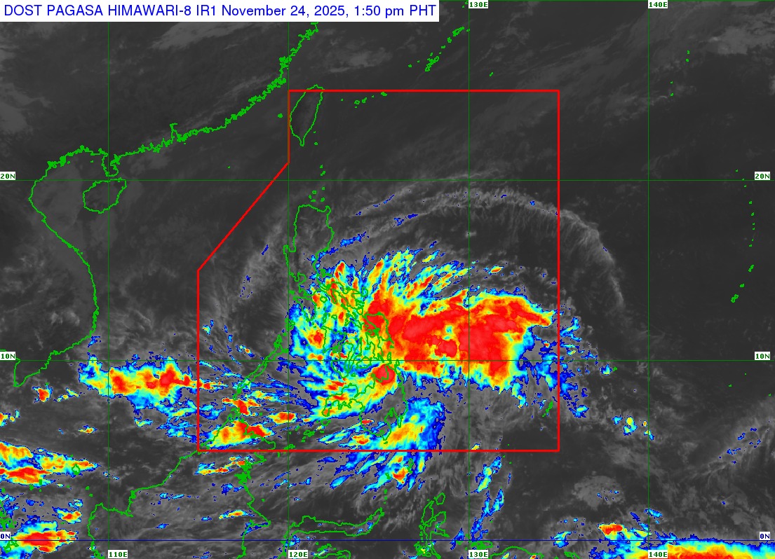
At precisely 1: 30 PM today, 24 November 2025, the calm was shattered as Tropical Depression Verbena made landfall over Bayabas, Surigao del Sur. This weather system, maintaining its strength with maximum sustained winds of 45 km/h near the centre and gustiness reaching up to 55 km/h, presents an immediate, escalating threat to wide swaths of the Philippines. For residents across the Visayas and key areas in Luzon and Mindanao, this is not merely a weather update but a critical alarm, signalling that preparedness must shift to action as the depression continues its swift track westward at 25 km/h, with strong winds already extending outwards up to 200 km from its estimated centre (09. 0°N, 126. 3°E). The severity of the wind threat, coupled with the storm’s imminent acceleration across the central portion of the country, demands attention. Immediate Impacts of Tropical Depression Verbena: Strong Winds and Sea Danger The Philippine Atmospheric, Geophysical and Astronomical Services Administration (PAGASA) has issued Tropical Cyclone Wind Signal (TCWS) No. 1 for an extensive area, signifying a 36-hour warning lead time for the onset of strong winds ranging from 39 to 61 km/h (Beaufort 6 to 7). This means minimal to minor threats to life and property are possible across all areas under the signal. Residents should be aware that unreinforced structures, older buildings, and houses made of very light materials may suffer minor roof damage. Furthermore, unsecured, exposed lightweight items could become dangerous projectiles. Areas currently under TCWS No. 1 include a significant portion of the country: Luzon: Occidental Mindoro, Oriental Mindoro, Romblon, the northern portion of Palawan (including Calamian, Cuyo, and Cagayancillo Islands), and mainland Masbate. Visayas: Antique, Aklan, Capiz, Iloilo, Guimaras, Negros Occidental, Negros Oriental, Siquijor, Cebu, Bohol, Samar, Eastern Samar, Biliran, Leyte, and Southern Leyte. Mindanao: Dinagat Islands, Surigao del Norte, Surigao del Sur, Agusan del Norte, Agusan del Sur, Camiguin, Misamis Oriental, and the northern portion of Bukidnon. Beyond the direct threat from Verbena’s circulation, the surge of the Northeast Monsoon will combine with the depression to bring strong to gale-force gusty conditions over areas notcurrently under any Wind Signal. This includes nearly all of Luzon and Visayas today and tomorrow, extending to parts of Mindanao, such as Surigao del Sur, Misamis Oriental, and Zamboanga del Norte. Mariners are facing exceptionally dangerous conditions. A Gale Warning is already in effect for the northern seaboard of Northern Luzon, with sea travel being ‘risky for all types or tonnage of vessels’ due to up to very rough seas (up to 4. 5 m) over the seaboard of Batanes. Rough seas (up to 4. 0 m) are also expected over the seaboards of Ilocos Norte, Ilocos Sur, and the western seaboard of Pangasinan. Small seacraft, including all types of motorbancas, are strongly advised not to venture out to sea across the extensive list of affected coastal waters where waves could reach up to 3. 5 m. All mariners must remain in port or seek safe harbour immediately. Verbena’s Intensification and Treacherous Trajectory The track and intensity outlook confirms that Verbena is expected to move generally west northwestward between today and tomorrow, 25 November. It will continue accelerating across the Visayas and the northern portion of Palawan this evening and tomorrow evening, before finally emerging over the West Philippine Sea on Wednesday morning, 26 November. The public must be aware that heavy rainfall and severe winds may still be experienced in localities outside the immediate landfall point and the narrow forecast confidence cone. While Verbena is forecast to likely cross the Visayas as a tropical depression, the crucial forecast element is its expected intensification. It may reach the Tropical Storm category either before reaching northern Palawan or once it hits the open waters of the West Philippine Sea. Furthermore, the storm may peak at Severe Tropical Storm category while in the middle of the West Philippine Sea, highlighting a long-term threat to the country’s western sea lanes before it is forecast to exit the Philippine Area of Responsibility on Thursday, 27 November. This bulletin, Tropical Cyclone Bulletin Nr. 4, was issued at 2: 00 PM. The next update is scheduled for 5: 00 PM today. Residents in flood-prone and highly susceptible areas are urged to heed all evacuation and safety instructions from local government officials.
https://www.ibtimes.co.uk/tropical-depression-verbena-makes-landfall-over-surigao-del-sur-very-rough-seas-45m-expected-1757506
Tropical Depression Verbena Makes Landfall Over Surigao Del Sur, Very Rough Seas Up To 4.5m Expected